- Solutions
- The Company
- About usCartrack offers smart fleet solutions guaranteed to optimise your fleet and workforce, no matter how big or small your business.
- Investor RelationsCartrack has a history of strong cash flow generation and cash conversion, low financial leverage and strong dividends.
- CareersCareers portal. View all the current Cartrack career openings and opportunities available.
- Resources
- Contact Us
- Login
Flood-Prone Areas in the Philippines? How Geofencing Protects Your Fleet in Bad Weather
Geofencing protects your fleet in bad weather and flood-prone areas by providing digital ‘fences’ around high-risk regions, so that drivers aren’t caught or stranded. This way, you can assess the projected path of a hazardous weather event and take quick action on behalf of your drivers, especially when weather patterns change or escalate.
Based on indices calculated between 2022 and 2025, the Philippines has been the most disaster-prone country for four years in a row.
In fact, the Philippines is at the top of the World Risk Index, ranking first with a disaster risk score of 46.56. Some of the densely populated areas considered extreme exposure zones include:
-
Metro Manila
-
Pampanga
-
Marikina
-
Bulacan
-
Cagayan Valley, and
-
Pangasinan
Risk analysis maps also point out these areas as particularly highly susceptible to monsoons and tropical storms.
Don’t let your most valuable assets—your vehicles and drivers—end up in untraversable streets when severe weather hits. Keep reading to understand the value of digital boundaries and how Cartrack’s high-end geofencing fleet management technology can propel your business’ safety to a whole new level.
Key takeaways
-
Geofencing allows fleet managers to draw virtual boundaries around flood-prone zones and landslide areas to keep drivers away from danger.
-
If a vehicle crosses into a high-risk zone, the system triggers an instant tracking alert so fleet managers can quickly take action to protect the driver.
-
Maintaining digital records of vehicles that enter storm zones allows you to pinpoint exactly which ones require urgent mechanical checks for any hidden damage.
-
Virtual perimeters can also be set around standard delivery depots and warehouses to automatically track arrival times, improve daily logistics, and meet standard compliance.
How does geofencing improve fleet safety during bad weather conditions?
Geofencing improves fleet safety during bad weather conditions by providing your drivers with a clear indication of where they should and shouldn’t go. You can preemptively create digital boundaries around unsafe areas (like regions prone to landslides or flash floods), while being able to update those areas in real time as the risk potentially increases.
You can skip the hassle of poring over a physical map when you assess your fleet vehicles' locations and avoid the stress of manually cross-referencing potential danger zones. You also get a complete bird’s-eye view of how assets are moving in relation to the shifting weather patterns.
Geofencing allows you to see if a vehicle is moving towards danger and lets you take immediate action.
Whether that immediate action means rerouting your drivers to safer areas or delaying the trip, you can rest assured knowing that you’ve taken the right, proactive step to keep your drivers and vehicles safe from harm.
Why is bad weather a threat to your fleet’s safety?
Bad weather is a threat to your fleet’s safety because all that’s most valuable to your business, i.e., your drivers, vehicles, and the cargo they carry, is put in great danger. The concerns go far beyond simple delivery and transportation delays. Severe weather threats are a serious crisis that needs to be handled with the utmost care.
Your drivers are navigating through hazardous conditions, meaning their visibility is reduced, their safety is at risk, and their vehicles face serious & costly damage. Vehicles that have prolonged exposure to floodwater could experience engine failure or breakdown of their electrical systems, leaving your drivers stranded.
Flash floods can impact road infrastructure, completely submerging the roads and concealing potholes & other damage. All of this can happen in mere MINUTES.
Finally, your drivers are left to deal with an extremely stressful situation. They’re forced to concentrate heavily and do their best to manage being stuck in an unsafe predicament, all while likely feeling panicked and overwhelmed.
All of the above = driver’s physical and mental fatigue, with the likelihood of increased human error.
What exactly is geofencing & how does it work?
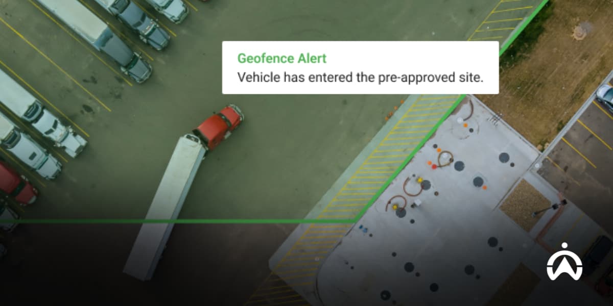
Geofencing is when a virtual boundary or ‘digital fence’ is set around certain areas. These areas can be high-risk zones, depots & warehouses, regular delivery zones, or any other locations that are important to your business.
When vehicles connected to the system move in and out of those geofenced zones, they trigger an action, like sending a notification.
Geofencing fleet management operates through a fleet system in combination with live GPS tracking. You create a perimeter on a map, and those perimeters can sometimes take the form of different shapes (depending on the type of perimeter you want to set).
With a map-based interface, the vehicles enter and exit those zones, triggering the notification that comes in whatever form you choose (in-app, email, etc.).
An example of a geofencing use case involving a fleet would be:
-
User: A manager in charge of cold-chain delivery trucks
-
Use case: A geofence is created around the main distribution centre to confirm (through alerts) arrival and unpacking times
Why is geofencing necessary for danger zones?
Geofencing is necessary for danger zones because it can proactively protect your drivers, vehicles, and cargo from the risks associated with severe weather. Geofencing fleet management can prove to be the ultimate tool for your fleet’s safety, especially when it comes to the unpredictable (and often frightening) weather patterns of the Philippines.
Geofencing takes your risk management from reactive to proactive, effectively allowing you to transform the safety profile of your fleet with the right technology at hand.
Think about this:
There’s a massive storm brewing outside. You’re being inundated with warnings and notifications about the rapidly changing weather. You don’t have geofencing, so you have to manage dozens of logistics vehicles manually. You’re panicked, confused, and likely to miss many of those fleet vehicles because of this time-sensitive, demanding task.
Geofencing fleet management handles that and ensures your fleet’s safety.
Because there are already dangerous zones that have been geofenced, you’ll immediately be notified if a fleet vehicle passes through that zone. Even if your drivers make the mistake of going into a high-risk area, their movements won’t go unnoticed.
This allows you to react quickly and take action.
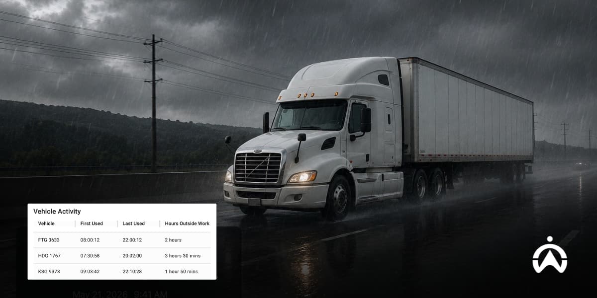
Post-weather damage control
Managing safety doesn’t stop just because the bad weather has passed. Because every entry and exit of a geofenced area is recorded, you’re able to export a comprehensive record of which vehicles passed through these dangerous areas and when.
From this, you can see which vehicles might need extra attention. You don’t have to waste time attempting to inspect the entire fleet.
The vehicles that were exposed to severe weather can be quickly scheduled for an extra inspection, so that any hidden water damage and electrical issues can be promptly caught before they become more costly.
How does Cartrack’s geofencing put you in control?
Cartrack’s geofencing puts you in control by giving you the necessary technology to keep your assets safe. We don’t just provide you with the geofencing feature alone, but a fully equipped fleet management platform that gives you a complete overview and acts as a data visibility hub.
A partnership with us is your key to total oversight and even better management.
Geofencing and flood risk management
With our geofencing fleet management technologies, you can completely customise your boundaries and update them in real time if necessary. Our boundaries are precise, adhering closely to the contours you’ve specifically set.
Your perimeters can be in the shape of a circle (general radius), a polygon (custom-shaped with multiple points to mark the exact area), or a route (along a path).
While you can see your custom weather zones overlaid with your fleet’s live positions, it doesn’t mean you have to stay glued to the screen. Receive instant vehicle tracking alerts when vehicles cross geofenced areas, and take swift action to mitigate risk and protect your team.
Beyond the bad weather: Round-the-clock protection
Severe weather isn’t the only major risk that geofencing can help you manage. What’s great about our geofencing fleet management solution is that it doesn’t stop at flood risk management; it protects your fleet all year round.
While Cartrack understands the importance of geofencing for severe weather, we know that protecting your business extends to safety from a compliance perspective. Critical zones can also refer to sensitive locations, like restricted areas and depots.
Our Points of Interest (POI) functionality can work as a complementary tool to geofencing by marking key areas that are easily identifiable on the map.
You can geofence those areas as well, carefully monitoring vehicle activity and receiving alerts when geofenced boundaries are crossed. This creates a valuable tool for your business that ensures necessary procedures are followed and your business remains compliant, accountable, and safe.
Final takeaway: Get ahead of the rainy season
The floods don’t have to catch you off guard, the landslides shouldn’t take you by surprise, and your fleet losses don’t have to be the result of just ‘bad luck’. You can take full control of your fleet’s safety and successfully manage its operational risks with the right technology.
A partnership with Cartrack is a long-term, future-forward, and protected one. Our geofencing system gives you the power to shield your fleet from the dangers (and expensive damage) that come with hazardous weather conditions. Both you and your drivers are clear on danger zones to avoid, and with the option to make adjustments in real time, you’re prepared for even the most abrupt weather changes.
Don't wait for the next storm to hit. Call Cartrack today and discover how our geofencing solutions can protect your fleet during the Metro Manila floods—and all year round.
Frequently asked questions about geofencing and bad weather
Is geofencing legal?
Yes, geofencing is legal, although it must be in line with standard data privacy acts according to the National Privacy Commission (NPC). Always remember to speak with your team, be transparent about GPS tracking solutions, and ensure their consent is explicit. Also, be transparent regarding how the geofencing information is to be used, i.e., for risk management purposes.
How small an area can geofencing cover?
The smallest area that geofencing can cover depends on the type of technology being used to create the geofence. With standard GPS tracking, it’ll likely cover a minimum radius of roughly 20 metres. On the other hand, it’s encouraged for you to set a geofence that’s a minimum of about 50-100 metres so that you don’t consistently trigger false alerts.
What’s the difference between geofencing and geotargeting?
The difference between geofencing and geotargeting is that geofencing is used to set a virtual boundary or zone around an area, while geotargeting is focused on targeting ads to specific demographics based on their location, interests, etc. Geofencing is a strong tool for fleets, while geotargeting is a strong tool for advertisers and marketers.
Is geofencing useful for logistics companies?
Yes, geofencing is useful for logistics companies, especially from a stricter control and business safety perspective. It helps ensure your fleet sticks to the right areas & routes, provides enhanced security by limiting threats, offers improved customer experiences by triggering ETA messages, and helps you be more operationally productive by giving you a competitive edge.
Can geofencing prevent flood-related vehicle damage?
Yes, geofencing can prevent flood-related vehicle damage by keeping fleet vehicles out of danger zones. If there aren’t geofenced risky areas and your drivers get caught in flash floods & severe weather storms for extended periods of time, they risk serious internal damage like engine failure, faulty electrical systems, physical damage to the outside of the vehicle, and more.
How does geofencing improve driver safety?
Geofencing improves driver safety by:
-
Keeping drivers away from unsafe areas
-
Allowing fleet managers to react quickly in triggered emergency situations
-
Helping fleet managers map out the safest designated routes, and
-
Implementing fatigue management strategies by logging entries and exits from designated rest stops, as geofencing helps with enforcing mandatory breaks


 Select Countries


